Predicting disease risk areas through co-production of spatial models: The example of Kyasanur Forest Disease in India's forest landscapes

Bethan V. Purse ,Narayanaswamy Darshan,Gudadappa S. Kasabi,France Gerard,Abhishek Samrat,Charles George,Abi T. Vanak,Meera Oommen,Mujeeb Rahman,Sarah J. Burthe,Juliette C. Young,Prashanth N. Srinivas,Stefanie M. Schäfer,Peter A. Henrys,Vijay K. Sandhya,M Mudassar Chanda,Manoj V. Murhekar,Subhash L. Hoti,Shivani K. Kiran

April 7, 2020
Paper Summary

Worldwide, impacts of zoonotic diseases, that cycle between animals and people, are concentrated in tropical communities and often linked to the way people use and change ecosystems. Interventions for zoonotic diseases could be targeted better using risk maps based on computer models that integrate social and ecological risk factors across degraded ecosystems.

However, such predictive models often perform poorly at local scales, incorporate narrow ranges of risk factors, and are disconnected from policy, managers and interventions. Co-production brings together stakeholders and knowledge, across the human health, animal health and environmental sectors, aligning with the OneHealth Initiative, to develop more informative predictive tools for zoonotic diseases.

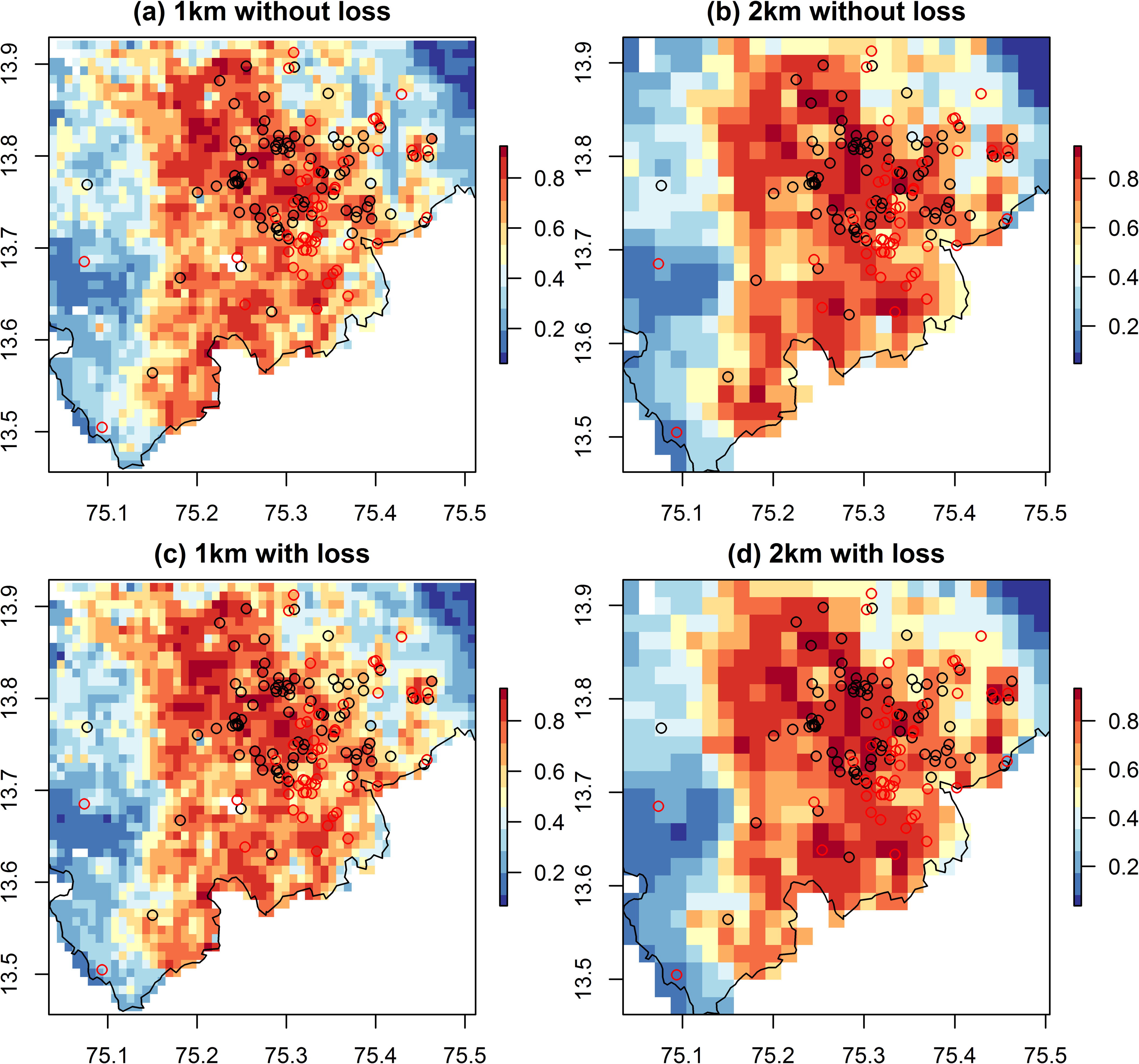
Through co-production, we develop predictive models for a fatal tick-borne disease, Kyasanur Forest Diseases (KFD) that is spreading across the degraded Western Ghats forest in India. These models incorporating contextual risk factors identified by stakeholders, accurately predicted patterns in human cases of KFD (2014–2018) in Shivamogga district, Karnataka State, and identified new hotspots of infection during the subsequent 2019 outbreak.

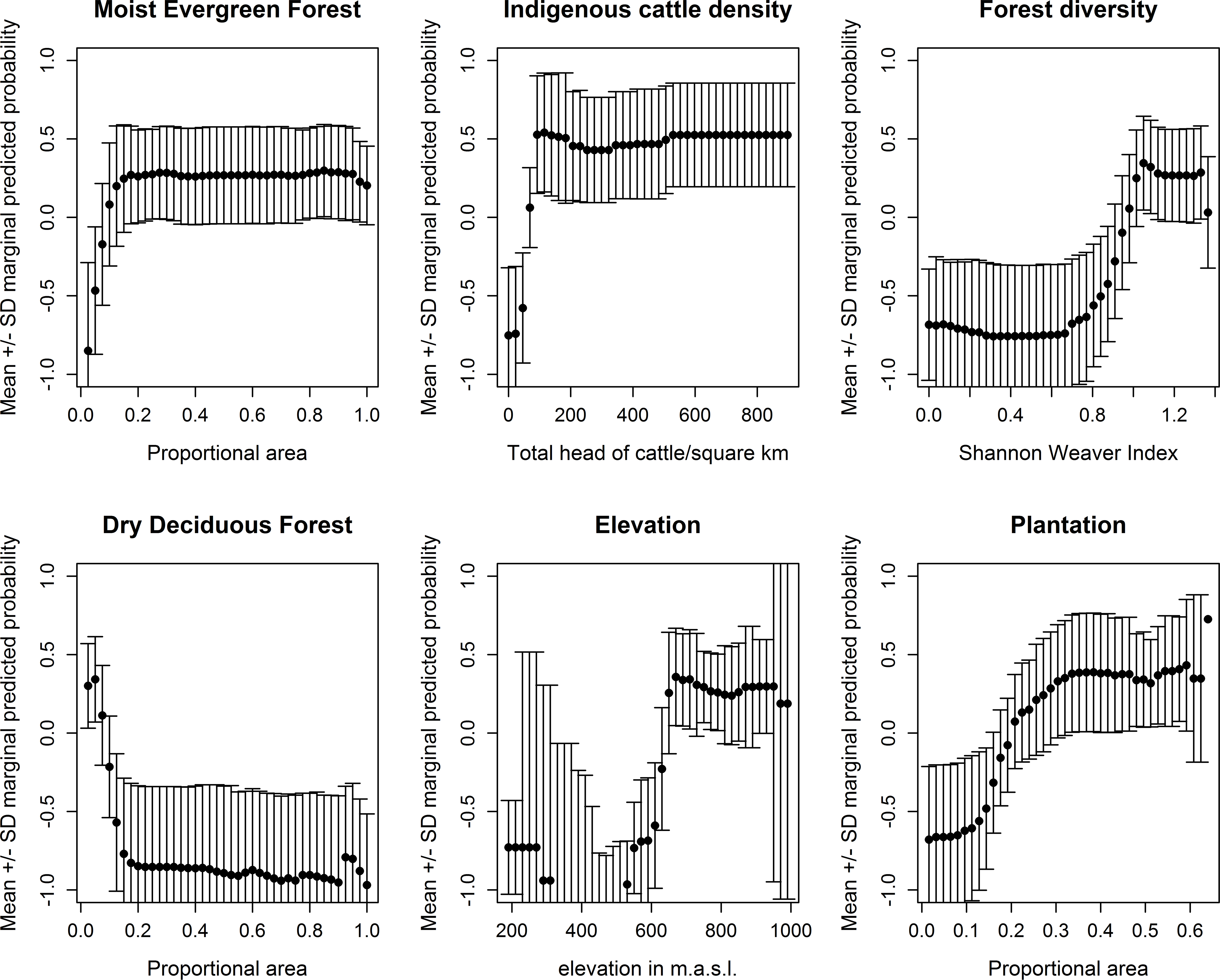
Landscapes at highest risk encompassed diverse forest-plantation mosaics with high coverage of moist evergreen forest and plantation, high indigenous cattle density, and low coverage of dry deciduous forest.

Co-production resulted in outbreak data that reflected where exposure occurred in the landscape and outputs of value for targeting of interventions, matched to the scale of forest use and public health interventions.

https://doi.org/10.1371/journal.pntd.0008179

Image
Figure from Predicting disease risk areas through co-production of spatial models

Marginal response plots for key predictors of presence of human cases of Kyasanur Forest Disease, from models at a 1 km resolution (without forest loss as a predictor)

Image
Figure from Predicting disease risk areas through co-production of spatial models

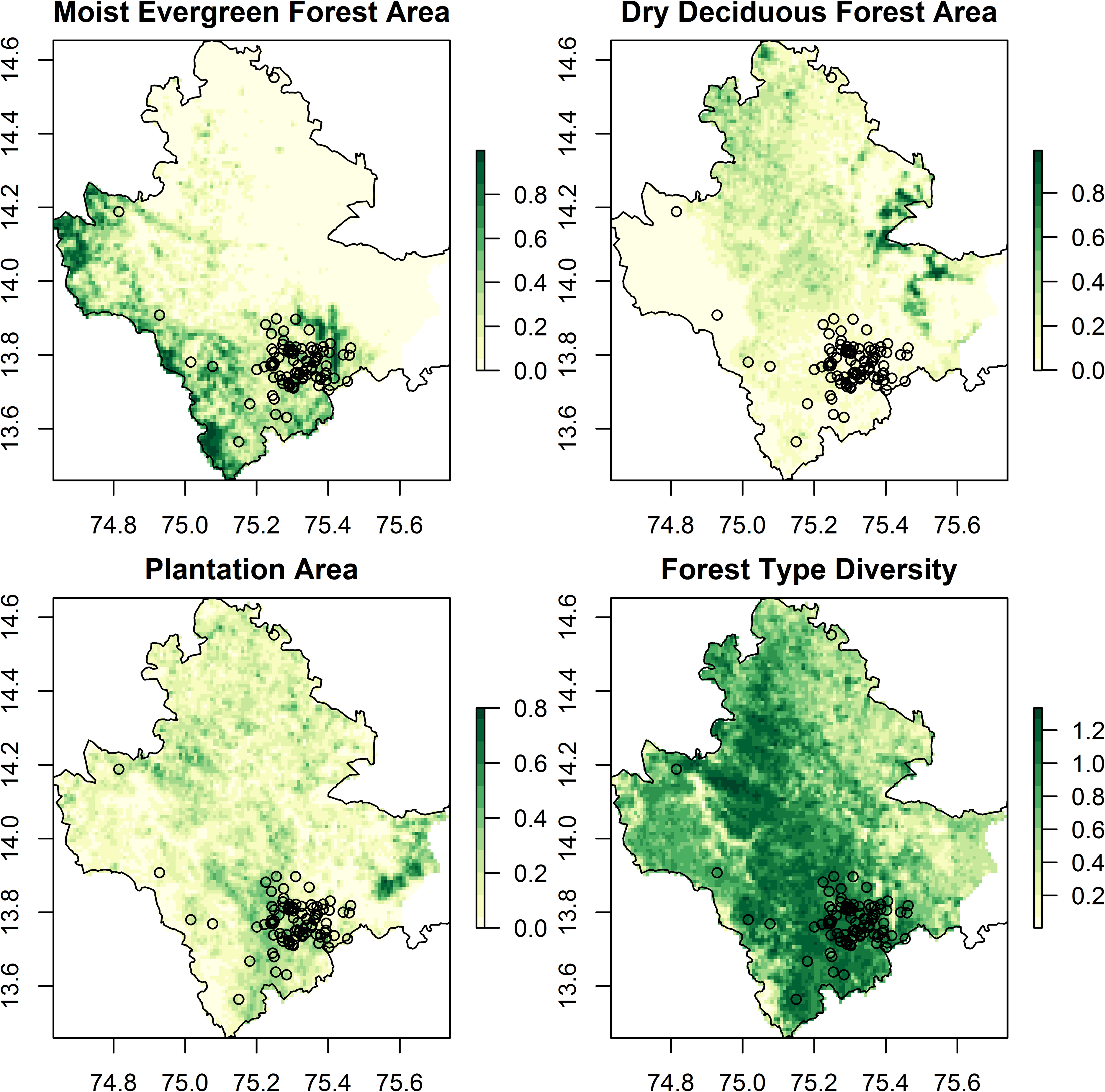
Key landscape predictors of presence of Kyasanur Forest Disease (1 km resolution) overlaid with point locations of human cases from 2014 to 2018 (black dots)

Citation

Purse BV, Darshan N, Kasabi GS, Gerard F, Samrat A, George C, et al. (2020) Predicting disease risk areas through co-production of spatial models: The example of Kyasanur Forest Disease in India’s forest landscapes. PLoS Negl Trop Dis 14(4): e0008179.


https://doi.org/10.1371/journal.pntd.0008179

Published:  April 7, 2020